The peak · FR · Mont Blanc Alps

Aiguille Verte

4,122 m

French for 'green needle' — the etymology is debated. The conventional reading is that 'verte' refers to the dark green-grey schist of the lower slopes (in contrast to the granite of the neighbouring Drus); a competing folk etymology traces it to a Savoyard personal name 'Berthe' that was Francised to 'verte' on the 19th-century maps.

Card
Coordinates45.9333° N · 6.9667° E
UIAA rank№ 47 / 82
CountriesFrance
Normal gradeAD · assez difficile
First ascent1865 · Edward Whymper, Christian Almer, Franz Biener
Typical seasonJuly to September
Sign in to log
Photo of Aiguille Verte
Photo: John Johnston · CC BY 2.0

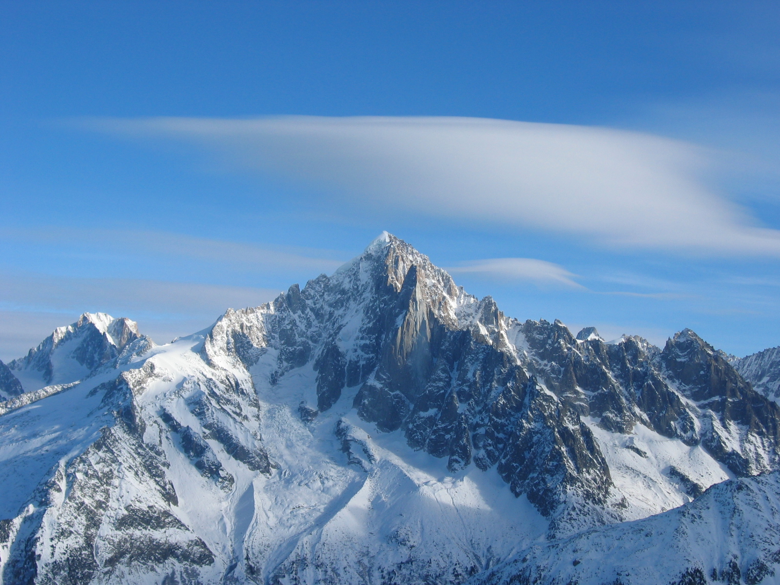
Iconic granite-and-ice peak above the Argentière basin in the Mont Blanc massif; its normal route is the Whymper Couloir on the south-east face.

History

On 29 June 1865 Edward Whymper, with the guides Christian Almer and Franz Biener, climbed the Verte by the steep snow couloir on its south face — now the Whymper Couloir — after three earlier attempts had been turned back. Chamonix's guides were furious that an Englishman with two Oberlanders had taken their mountain, and Whymper was briefly hounded out of the village. Just nineteen days later he made the first ascent of the Matterhorn. The Verte is one of the few 4000ers without an easy route: every line involves serious mixed or ice climbing, and Chamonix guides traditionally say a climber is not a real alpinist until they have stood on its summit.

Location

Summit · huts that serve as bases for routes on this peak

Major routes
Whymper Couloir (south face, easiest route)
Vertical / summit day1,400 m gain · 9h
Whymper's 1865 first-ascent line and the least-difficult route up the Verte — but still a serious face, not a forgiving one. From the Couvercle hut the route climbs the Talèfre glacier to the foot of the Whymper Couloir, then 600 m of 50–55° snow/ice to the summit ridge. Best in good névé conditions in late spring; very dangerous in summer when stone-fall and bare ice make it brutal.
Sections
Montenvers (1913 m)Refuge du Couvercle (2687 m)+774 m3h
Refuge du CouvercleFoot of couloir (~3500 m)+813 m4h
Foot of couloirSummit (4122 m)+622 m5h
Huts on this route
Couturier Couloir (NW face)
D · difficileTopo ↗
Vertical / summit day1,100 m gain · 8h
A classic snow/ice line on the NW face. Sustained 45–60° (steepest at the rock fin two-thirds up), descended to or from the Argentière hut. A go-to spring ski-mountaineering descent and one of the great alpine ice classics.
Huts on this route
Arête des Grands Montets (NNE ridge)
D-
Vertical / summit day1,100 m gain · 8h
Mixed snow-and-rock ridge from the Grands Montets cable car / Argentière hut. Sustained III with one or two harder pitches; an aesthetic alternative to the couloirs and the most common ascent line today.
Huts on this route
Nearby huts
Refuge des CosmiquesCAF · year-round3,613 mRefuge du CouvercleCAF · mid-June to mid-September2,687 mRefuge d'ArgentièreCAF · mid-June to mid-September2,771 mRefuge d'ArgentièreCAF · mid-March to mid-September2,771 mRefuge de la CharpouaCAF · late June to mid-September2,841 m